
Arbatax
Arbatax
Arbatassa (Sardinian) | |
|---|---|
Frazione of Tortolì | |
 | |
 Arbatax Location in Sardinia | |
| Coordinates: 39°55′37″N 9°42′07″E / 39.927°N 9.702°E | |
| Country | Italy |
| Region | Sardinia |
| County | Municipality of Tortolì |
| City | Tortolì |
| Population | |
| • Total | 5,000 |
Arbatax (Italian pronunciation: [arbaˈtaks];[1] Sardinian: Arbatassa) is the largest hamlet (frazione) of Tortolì, Sardinia, in Italy with a population of almost 5,000 inhabitants.
History
The origin of the name Arbatax is uncertain. According to tradition, it is derived from an Arabic word, which means "14th Tower", and refers to the nearby watchtower built by the Spaniards to protect the territory from the incursion of Arab pirates.[2]
The founders of Arbatax were Campanian fishermen from the island of Ponza, located in Lazio, close to the coast of the Italian Peninsula.
The location assumed importance in the 1960s after the construction of the main Sardinian paper mill.
Geography
The town is situated by the Tyrrhenian Sea, 5 km east of Tortolì.
Climate
| Climate data for Arbatax (Cape Bellavista) (1991–2020) | |||||||||||||
|---|---|---|---|---|---|---|---|---|---|---|---|---|---|
| Month | Jan | Feb | Mar | Apr | May | Jun | Jul | Aug | Sep | Oct | Nov | Dec | Year |
| Record high °C (°F) | 24.0 (75.2) |
27.0 (80.6) |
31.4 (88.5) |
29.4 (84.9) |
31.2 (88.2) |
38.4 (101.1) |
39.8 (103.6) |
40.8 (105.4) |
36.4 (97.5) |
31.0 (87.8) |
26.8 (80.2) |
27.0 (80.6) |
40.8 (105.4) |
| Mean daily maximum °C (°F) | 14.2 (57.6) |
14.6 (58.3) |
16.7 (62.1) |
19.2 (66.6) |
23.0 (73.4) |
27.6 (81.7) |
30.9 (87.6) |
31.5 (88.7) |
27.5 (81.5) |
23.4 (74.1) |
18.4 (65.1) |
15.2 (59.4) |
21.8 (71.2) |
| Daily mean °C (°F) | 11.1 (52.0) |
11.2 (52.2) |
12.9 (55.2) |
15.2 (59.4) |
18.6 (65.5) |
23.0 (73.4) |
26.1 (79.0) |
26.8 (80.2) |
23.2 (73.8) |
19.6 (67.3) |
15.2 (59.4) |
12.2 (54.0) |
17.9 (64.2) |
| Mean daily minimum °C (°F) | 8.1 (46.6) |
7.9 (46.2) |
9.5 (49.1) |
11.5 (52.7) |
14.8 (58.6) |
18.8 (65.8) |
21.8 (71.2) |
22.5 (72.5) |
19.3 (66.7) |
16.2 (61.2) |
12.3 (54.1) |
9.3 (48.7) |
14.3 (57.7) |
| Record low °C (°F) | −1.4 (29.5) |
−6.6 (20.1) |
1.0 (33.8) |
5.2 (41.4) |
6.4 (43.5) |
0.0 (32.0) |
15.6 (60.1) |
14.6 (58.3) |
11.4 (52.5) |
7.4 (45.3) |
2.2 (36.0) |
−1.6 (29.1) |
−6.6 (20.1) |
| Average precipitation mm (inches) | 39.5 (1.56) |
28.8 (1.13) |
33.9 (1.33) |
37.6 (1.48) |
22.5 (0.89) |
8.2 (0.32) |
5.0 (0.20) |
13.7 (0.54) |
41.3 (1.63) |
57.1 (2.25) |
64.0 (2.52) |
56.7 (2.23) |
408.4 (16.08) |
| Average precipitation days (≥ 1.0 mm) | 4.4 | 3.6 | 4.4 | 4.5 | 3.7 | 1.6 | 1.0 | 1.7 | 4.3 | 4.4 | 5.4 | 5.2 | 44.1 |
| Average relative humidity (%) | 70.3 | 68.1 | 69.6 | 69.8 | 69.6 | 68.8 | 68.6 | 69.1 | 69.2 | 71.4 | 70.7 | 69.5 | 69.6 |
| Mean monthly sunshine hours | 160.0 | 180.0 | 212.7 | 231.3 | 281.5 | 316.8 | 341.0 | 316.5 | 235.2 | 206.5 | 160.2 | 160.0 | 2,801.6 |
| Source: NOAA[3] | |||||||||||||
Transport
The port is used by ferries to and fro Civitavecchia and Olbia, and is also monopolized by the marine construction company Intermare, which builds gas rigs and vessels. The marina is one of the cheapest in Sardinia.
The town is connected to Lanusei and Cagliari by a narrow gauge railway, today used for touristic purposes, owned by Ferrovie della Sardegna.
The closest airport is the Tortolì Airport, about 4 km from the town.
Economy
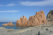
Today, the economy is focused on tourism and industry. Arbatax is home to a factory dedicated to the building of oil platforms, controlled by the Italian oil and gas industry contractor Saipem. Mussels are farmed in the nearby lagoon and fresh fish are on sale from the fishing cooperative. The red rocks are a tourist attraction.
Gallery
-
 Port
Port -
 Spanish tower
 -
 Beach of Rocce Rosse
 -
 Rocce Rosse / Red Rocks
 -
 Red Rocks - detail
.jpg)


See also
References
- ^ Bruno Migliorini (ed.). "Turandot". Dizionario italiano multimediale e multilingue d'ortografia e di pronunzia (in Italian). Archived from the original on 21 March 2022. Retrieved 8 August 2019.
- ^ "Sulla presenza araba in Sardegna e sulle sue conseguenze linguistiche, si vedano però le considerazioni di V. Brugnatelli, "Un nuovo arabismo sardo". Studi Mediolatini e Volgari 28 (. 1981.
{{cite web}}: Missing or empty|url=(help) - ^ "World Meteorological Organization Climate Normals for 1991-2020 — Cape Bellavista". National Oceanic and Atmospheric Administration. Retrieved February 4, 2024.
External links
- Tortolì-Arbatax Airport (IT)
- Comune of Tortolì (IT)
- Arbatax on marenostrum.it (IT)
- Arbatax on Sardegna.net (IT)
- "Port and coastal towers of Arbatax". Sardegna Virtual Archaeology. Retrieved 2021-08-28.
| International | |
|---|---|
| National | |