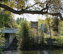
Algonquins of Pikwàkanagàn First Nation
This article includes a list of general references, but it lacks sufficient corresponding inline citations. (February 2018) |
Algonquins of Pikwàkanagàn First Nation
Pikwàkanagàn Omàmiwininiwak | |
|---|---|
| Pikwakanagan (Golden Lake 39) Indian Reserve | |
 | |
| Coordinates: 45°33′N 77°13′W / 45.550°N 77.217°W | |
| Country | |
| Province | |
| County | Renfrew |
| First Nation | Algonquins of Pikwàkanagàn |
| Area | |
| • Land | 7.45 km2 (2.88 sq mi) |
| Population (2011)[1] | |
| • Total | 432 |
| • Density | 58.0/km2 (150/sq mi) |
| Website | www.algonquinsof pikwakanagan.com |
The Algonquins of Pikwàkanagàn First Nation (Algonquin: Pikwàkanagàn Omàmiwininiwak), formerly known as the Golden Lake First Nation, are an Algonquin First Nation in Ontario, Canada. Their territory is located in the former township of South Algona (now part of Bonnechere Valley) in the Ottawa Valley on Golden Lake.
As of October, 2008, the registered population of the First Nation was 1,992 people, of which only 406 people lived on their own reserve.
Reserve
The First Nation have reserved for themselves the Pikwakanagan Indian Reserve, formerly known as Golden Lake 39 Indian Reserve. Their reserve of 688.8 hectares (1,702 acres) is adjacent to the hamlet of Golden Lake which is located between the villages of Killaloe and Eganville, about 40 kilometres (25 mi) south of Pembroke. The land straddles the south shores of Golden Lake and the Bonnechere River.
References
- ^ a b "Pikwakanagan (Golden Lake 39) census profile". 2011 Census of Population. Statistics Canada. Retrieved 17 June 2015.


