
Alaminos, Pangasinan
Alaminos | |
|---|---|
| City of Alaminos | |
  Clockwise from top: Christ the Redeemer at Hundred Islands National Park, Saint Joseph the Patriarch Cathedral Cathedral, and Alaminos city center (Poblacion). | |
 Flag  Seal | |
| Nickname: Home of the Hundred Islands | |
 Map of Pangasinan with Alaminos highlighted | |
OpenStreetMap  | |
.svg) Alaminos Location within the Philippines | |
| Coordinates: 16°09′19″N 119°58′51″E / 16.155314°N 119.980769°E | |
| Country | Philippines |
| Region | Ilocos Region |
| Province | Pangasinan |
| District | 1st district |
| Founded | 1744 |
| Cityhood | March 28, 2001 |
| Named for | Juan Alaminos y Vivar |
| Barangays | 39 (see Barangays) |
| Government | |
| • Type | Sangguniang Panlungsod |
| • Mayor | Arth Bryan C. Celeste (NP) |
| • Vice Mayor | Jose Antonio Miguel Y. Perez (NP) |
| • Representative | Noli Celeste (NP) |
| • City Council | Members |
| • Electorate | 62,546 voters (2022) |
| Area | |
| • Total | 164.26 km2 (63.42 sq mi) |
| Elevation | 14 m (46 ft) |
| Highest elevation | 760 m (2,490 ft) |
| Lowest elevation | 0 m (0 ft) |
| Population (2020 census)[3] | |
| • Total | 99,397 |
| • Density | 610/km2 (1,600/sq mi) |
| • Households | 25,195 |
| Economy | |
| • Income class | 4th city income class |
| • Poverty incidence | 7.75 |
| • Revenue | ₱ 703.1 million (2020) |
| • Assets | ₱ 1,925 million (2020) |
| • Expenditure | ₱ 613 million (2020) |
| • Liabilities | ₱ 460.6 million (2020) |
| Service provider | |
| • Electricity | Pangasinan 1 Electric Cooperative (PANELCO 1) |
| Time zone | UTC+8 (PST) |
| ZIP code | 2404 |
| PSGC | |
| IDD : area code | +63 (0)75 |
| Native languages | Pangasinan Ilocano Tagalog Sambal |
| Website | www |
Alaminos, officially the City of Alaminos (Pangasinan: Siyudad na Alaminos; Ilocano: Siudad ti Alaminos; Sambal: Babali nin Alaminos; Filipino: Lungsod ng Alaminos), is a 4th class component city in the province of Pangasinan, Philippines, and is known for being the home of the Hundred Islands National Park, which is composed of 124 islands and is located off the coast of Barangay Lucap. According to the 2020 census, it has a population of 99,397 people.[3] The city is named after Juan Alaminos y de Vivar, a former governor-general of the Philippines.
In 2009, it was announced that Alaminos Airport would be built near the city as a commercial airport for Pangasinan province.[5] However, the timeline for construction of the airport has repeatedly slipped; as of 2015, the project is in limbo.[6]
Etymology
Alaminos is named after the Spanish general Juan Alaminos y Vivar, who served as Governor-General of the Philippines from 1873 to 1874 and was much loved by locals as he visited to the then-town in 1860. Previously named Sarapsap, it was renamed in his honor in 1872.[7]
History
Alaminos was formerly part of Bolinao, tracing its roots to a barrio named Casborran (present-day barangay Baleyadaan), formerly part of Zambales. It eventually grew when people from Suyang (present-day barangay Zaragosa in Bolinao) relocated to the area in 1737.
In 1747, Casborran became an independent town. In 1758, it was attacked by fire due to a political and economic conflict. In 1764, inhabitants tried to rebuild the town but another conflict happened, making them leave for Nansangaan (present-day Barangay Inerangan). Two years later, they found refuge at a plateau that is now the poblacion of Alaminos and renamed it Sarapsap. It was renamed to Alaminos in 1872, twelve years after the visit of the future Governor-General Juan Alaminos y Vivar, who was well loved by residents, to the thriving town.[7] In 1903, Alaminos was annexed to Pangasinan by virtue of Act No. 1004.[8]
The Communist Party of the Philippines was founded by Jose Maria Sison in the remote barangay of Dulacac on December 26, 1968.[9]
Cityhood

By virtue of Republic Act 9025, signed by President Gloria Macapagal Arroyo on March 5, 2001, Alaminos was converted into a city after 85% of the voters favored the ratification in a plebiscite held on March 28, 2001.[7][10]
Contermporary era
Alaminos was badly hit in May 2009 by Typhoon Emong which damaged many houses in the city, including the roof of the main church. Due to this, several organizations had requested donations and aid to help in restoring the town back to its former self.[11]
Geography
Alaminos City is 42 kilometres (26 mi) from Lingayen and 248 kilometres (154 mi) from Manila.
Barangays
Alaminos City is politically subdivided into 39 barangays. Each barangay consists of puroks and some have sitios.
- Alos
- Amandiego
- Amangbangan
- Balangobong
- Balayang
- Bisocol
- Bolaney
- Baleyadaan
- Bued
- Cabatuan
- Cayucay
- Dulacac
- Inerangan
- Landoc
- Linmansangan
- Lucap
- Maawi
- Macatiw
- Magsaysay
- Mona
- Palamis
- Pandan
- Pangapisan
- Poblacion
- Pocal-Pocal
- Pogo
- Polo
- Quibuar
- Sabangan
- San Antonio
- San Jose
- San Roque
- San Vicente
- Santa Maria
- Tanaytay
- Tangcarang
- Tawintawin
- Telbang
- Victoria
Climate
| Climate data for Alaminos | |||||||||||||
|---|---|---|---|---|---|---|---|---|---|---|---|---|---|
| Month | Jan | Feb | Mar | Apr | May | Jun | Jul | Aug | Sep | Oct | Nov | Dec | Year |
| Mean daily maximum °C (°F) | 31 (88) |
31 (88) |
33 (91) |
34 (93) |
34 (93) |
33 (91) |
32 (90) |
31 (88) |
31 (88) |
32 (90) |
31 (88) |
31 (88) |
32 (90) |
| Mean daily minimum °C (°F) | 21 (70) |
21 (70) |
23 (73) |
25 (77) |
25 (77) |
25 (77) |
25 (77) |
24 (75) |
24 (75) |
24 (75) |
23 (73) |
22 (72) |
24 (74) |
| Average rainfall mm (inches) | 4.3 (0.17) |
19.1 (0.75) |
27.3 (1.07) |
45.2 (1.78) |
153.3 (6.04) |
271.3 (10.68) |
411.1 (16.19) |
532 (20.9) |
364.4 (14.35) |
182.5 (7.19) |
56.3 (2.22) |
24.4 (0.96) |
2,091.2 (82.3) |
| Average rainy days | 3 | 2 | 3 | 5 | 14 | 17 | 22 | 23 | 21 | 13 | 7 | 4 | 134 |
| Source: World Weather Online (modeled/calculated data, not measured locally)[12] | |||||||||||||
Demographics
|
|
| ||||||||||||||||||||||||||||||||||||||||||||||||||||||
| Source: Philippine Statistics Authority[13][14][15] | ||||||||||||||||||||||||||||||||||||||||||||||||||||||||
Economy
Graphs are unavailable due to technical issues. There is more info on Phabricator and on MediaWiki.org. |
Government
Local government
Alaminos, belonging to the first congressional district of the province of Pangasinan, is governed by a mayor designated as its local chief executive and by a municipal council as its legislative body in accordance with the Local Government Code. The mayor, vice mayor, and the councilors are elected directly by the people through an election which is being held every three years.
Elected officials
| Position | Name |
|---|---|
| District Representative (1st Legislative District the Province of Pangasinan) |
Arnold F. Celeste |
| Chief Executive of the City of Alaminos | Arth Bryan C. Celeste |
| Presiding Officer of the City Council of Alaminos | Vice Mayor Jose Antonio M. Yatco |
| Councilors of the City of Alaminos | Apple Joy D. Bacay |
| Carolyn D. Sison | |
| Michelle S. Segundera | |
| Joselito D. Fontelera | |
| Cirilo B. Radoc | |
| Verna S. Rabago | |
| Oscar A. Boling | |
| Froebel A. Ranoy | |
| Dahlia M. De Leon | |
| Alfred Feliz E. De Castro |
Media
AM Stations:
FM Stations:
- 99.3 Spirit FM (Catholic Media Network)
- 100.1 Radyo Natin (Manila Broadcasting Company)
- 102.7 Big Sound FM (Vanguard Radio Network)
Cable & Satellite TV Providers
Festivals
The Galila Hundred Islands Festival is held from March 16 to 21 every year.[24][25] Galila means “come” in the vernacular, and the festival includes the 100 Islands Adventure Race.
Transportation
Accredited Transport Cooperative as of January 2021:
- Alaminos, Bani, Agno, Anda, Bolinao Operators and Drivers Transport Service Cooperative (ABAABOD TSC)[26]
Sister cities
Images
-
 Welcome sign
 -
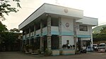
 Alaminos City Hall (Poblacion)
 -
 Legislative Building (Sangguniang Bayan Session Hall)
 -
 Colegio San Jose de Alaminos (Poblacion)
 -
 Cathedral of Saint Joseph (Poblacion)
 -
 Remote view of Alaminos City skyline


References
- ^ City of Alaminos | (DILG)
- ^ "2015 Census of Population, Report No. 3 – Population, Land Area, and Population Density" (PDF). Philippine Statistics Authority. Quezon City, Philippines. August 2016. ISSN 0117-1453. Archived (PDF) from the original on May 25, 2021. Retrieved July 16, 2021.
- ^ a b Census of Population (2020). "Region I (Ilocos Region)". Total Population by Province, City, Municipality and Barangay. Philippine Statistics Authority. Retrieved July 8, 2021.
- ^ "PSA Releases the 2018 Municipal and City Level Poverty Estimates". Philippine Statistics Authority. December 15, 2021. Retrieved January 22, 2022.
- ^ Micua, Leonardo V. (July 23, 2011). "Alaminos City finally chosen as site of commercial airport in Pangasinan". Archived from the original on July 24, 2011. Retrieved September 17, 2009.
- ^ Sotelo, Yolanda (August 5, 2015). "Airport, seaport projects hit gridlock in Pangasinan". Philippine Daily Inquirer.
- ^ a b c "Local History". City of Alaminos Pangasina. Retrieved July 7, 2023.
- ^ Act No. 1004 (November 20, 1903), An Act Annexing the Northern Part of the Province of Zambales to the Province of Pangasinan and Providing That the Southern Part Thereof Shall Continue as Separate Province Under the Name of Zambales, retrieved July 7, 2023 – via Senate of the Philippines Legislative Digital Resources
- ^ Joma Sison recalls birth of CPP in Alaminos - INQUIRER.net, Philippine News for Filipinos Archived December 26, 2014, at the Wayback Machine
- ^ Republic Act No. 9025 (March 5, 2001), An Act Converting The Municipality Of Alaminos, Province Of Pangasinan Into A Component City To Be Known as the City of Alaminos, retrieved June 30, 2021 – via officialgazette.gov.ph
- ^ ""Emong" wreaks havoc in Western Pangasinan". Sunday Punch. May 10, 2009. Archived from the original on April 19, 2021. Retrieved April 19, 2021.
- ^ "Alaminos, Philippines: Average Temperatures and Rainfall". World Weather Online. Retrieved September 15, 2014.
- ^ Censuses of Population (1903–2007). "Region I (Ilocos Region)". Table 1. Population Enumerated in Various Censuses by Province/Highly Urbanized City: 1903 to 2007. National Statistics Office.
{{cite encyclopedia}}: CS1 maint: numeric names: authors list (link) - ^ Census of Population and Housing (2010). "Region I (Ilocos Region)" (PDF). Total Population by Province, City, Municipality and Barangay. National Statistics Office. Retrieved June 29, 2016.
- ^ Census of Population (2015). "Region I (Ilocos Region)". Total Population by Province, City, Municipality and Barangay. Philippine Statistics Authority. Retrieved June 20, 2016.
- ^ "Poverty incidence (PI):". Philippine Statistics Authority. Retrieved December 28, 2020.
- ^ "Estimation of Local Poverty in the Philippines" (PDF). Philippine Statistics Authority. November 29, 2005.
- ^ "2003 City and Municipal Level Poverty Estimates" (PDF). Philippine Statistics Authority. March 23, 2009.
- ^ "City and Municipal Level Poverty Estimates; 2006 and 2009" (PDF). Philippine Statistics Authority. August 3, 2012.
- ^ "2012 Municipal and City Level Poverty Estimates" (PDF). Philippine Statistics Authority. May 31, 2016.
- ^ "Municipal and City Level Small Area Poverty Estimates; 2009, 2012 and 2015". Philippine Statistics Authority. July 10, 2019.
- ^ "PSA Releases the 2018 Municipal and City Level Poverty Estimates". Philippine Statistics Authority. December 15, 2021. Retrieved January 22, 2022.
- ^ "2019 National and Local Elections" (PDF). Commission on Elections. Retrieved March 6, 2022.
- ^ Galila Hundred Islands Festival
- ^ "Gali-La Alaminians". Facebook.
- ^ "Accredited Transport Cooperatives as of January 2021" (PDF). Office of Transportation Cooperatives. January 2021.
- ^ "Alaminos donates goods in Marikina". Balita. September 2009. Archived from the original on February 19, 2017. Retrieved February 20, 2015.
External links
- Official website
- City Profile at the National Competitiveness Council of the Philippines
- Alaminos at the Pangasinan Government Website
- Local Governance Performance Management System
- Philippine Standard Geographic Code
- Philippine Census Information
Places adjacent to Alaminos, Pangasinan | |
|---|---|

| Authority control databases: National |
|---|